I've written on more than one occasion about the great maps that National Geographic produces for adventure travelers and hikers. Those maps are durable, offer tons of information, and take up almost no room in your backpack. Now, the convenience of those maps is coming to a handheld GPS device thanks to a collaborative partnership between Nat Geo and Satmap Systems, who are making the new Active 10 TREK GPS system available this week.
The Active 10 TREK will retail for $369.99 and comes preloaded with U.S. and World Base Maps, with the National Geographic Maps being made available on SD cards for $99 each. Those additional maps include the Topo! USGS topographic map series, the AdventureMap series of international adventure travel maps, as well as the National Geographic’s premier Trails Illustrated series of maps, which are being made available for the first time on any GPS device. Those maps focus on national parks, national forests and many popular recreation areas, and are an excellent resource for hikers and backpackers.
Satmap is a well known and respected manufacturer of GPS devices in Europe, but is just now venturing into the North American market. Partnering with National Geographic has given them a leg up on the competition already, as they will now have access to content that no other GPS company has. Their handheld devices are used for everything from mountain rescue to geocaching, and just about everything in between.
In total, there will be 14 different Topo! series map packs available at launch covering the following states: Arizona, California, Colorado, Idaho, the Mid-Atlantic region, Montana, Nevada, New England, New Mexico, North and South Carolina, Oregon, Utah, Washington and Wyoming. The remaining states will be made available in the first quarter of 2011. Three SD cards containing the Trails Illustrated maps will be available as well covering California’s Sierra Nevada, the Southern Appalachians and America’s “Greatest National Parks," with more to follow soon as well.
To check out the Active 10 TREK GPS device in more detail click here and to get more information on the Nat Geo maps that are available on SD cards click here. The device also has several accessories available including a Bike Mount, Vehicle Mount and a Deluxe Carry Case, which retail from $14.99.
This looks like a really promising handheld system that when combined with the National Geographic maps packs could become quite a great resource for outdoor enthusiasts of all types. I'm working on getting my hands on one to review, so hopefully I can post some thoughts soon. As a gear and gadget fan, who also loves Nat Geo, I have high hopes for the Active 10 TREK. Stay tuned for more soon.
Showing posts with label Maps. Show all posts
Thursday, November 18, 2010
Wednesday, October 20, 2010
Nat Geo Offers Expanded Line of AdventureMaps
Last week Nat Geo Maps, the arm of the National Geographic Society that oversees the production of all the great map products that the organization produces, announced that they are expanding their line of AdventureMaps, adding nearly 60 new destinations before 2012.
As of now, AdventureMaps mostly covers Central America, the Caribbean, and the various trekking regions of Nepal. But the new maps will expand the coverage to include parts of Europe, Africa, Southeast Asia, the Middle East, South America and beyond. The first new maps are expected to begin shipping next month, with 30 new regions covered by next summer. Amongst the new destinations are Argentina, Bali/Lombok/Komodo, Brazil, Chile, El Salvador/Nicaragua/Honduras, Ireland, Mexico, New Zealand, South Africa and Thailand.
The line of AdventureMaps are especially geared well for the adventure traveler, offering all kinds of great information such as top surf destinations, dive sites, kayak put-ins, hiking trails and more. The maps are water proof and tear resistant, and use biodegradable paper that is environmentally friendly, and they fold down to a small footprint while still offering an abundance of helpful information.
I personally own a couple of these maps and think they are wonderful. They really do offer some great info for adventure travelers and I'm always impressed with how durable and useful they are. I'm excited to hear that they are expanding the line to include some great new destinations, and if you're planning a trip abroad in the near future, you may want to consider checking adding one of these maps to your packing list. At $11.95, they really are a great bargain.
As of now, AdventureMaps mostly covers Central America, the Caribbean, and the various trekking regions of Nepal. But the new maps will expand the coverage to include parts of Europe, Africa, Southeast Asia, the Middle East, South America and beyond. The first new maps are expected to begin shipping next month, with 30 new regions covered by next summer. Amongst the new destinations are Argentina, Bali/Lombok/Komodo, Brazil, Chile, El Salvador/Nicaragua/Honduras, Ireland, Mexico, New Zealand, South Africa and Thailand.
The line of AdventureMaps are especially geared well for the adventure traveler, offering all kinds of great information such as top surf destinations, dive sites, kayak put-ins, hiking trails and more. The maps are water proof and tear resistant, and use biodegradable paper that is environmentally friendly, and they fold down to a small footprint while still offering an abundance of helpful information.
I personally own a couple of these maps and think they are wonderful. They really do offer some great info for adventure travelers and I'm always impressed with how durable and useful they are. I'm excited to hear that they are expanding the line to include some great new destinations, and if you're planning a trip abroad in the near future, you may want to consider checking adding one of these maps to your packing list. At $11.95, they really are a great bargain.
Labels:
Adventure Travel,
Maps,
National Geographic,
Travel
Friday, October 1, 2010
Google Street View Comes To Antarctica
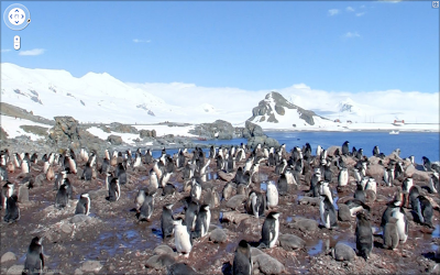
Google Street View has been a popular enhancement to the Google Maps system over the past few years. Street View allows us to look up places on the map, then drop into an interactive image that actually shows us that location. Google managed to create the system by sending specially designed vehicles on roads all over the country to take pictures of locations while they drove. The result is a handy tool that only further enhances the Maps programs.
Yesterday, Google announced that Street View is now available on all seven continents, with images from Antarctica now available. But don't worry, they didn't send one of the vehicles down there to go rampaging through the environment, snapping photos of startled penguins along the way. Instead, Brian McClendon, VP of Engineering at Google Earth and Maps made the trip with his wife recently and took plenty of photos to add to the collection. Brian and Mrs. McClendon actually took a trek across Half Moon Island, and then shared their vacation pictures with the world.
I'm a big fan of Google Maps, and have been using it ever since it was released. Street View was kind of icing on the cake, but it is a nice enhancement. It's kind of cool that they now have images from every continent though, but it's making me want to visit Antarctica all that much more.
Yesterday, Google announced that Street View is now available on all seven continents, with images from Antarctica now available. But don't worry, they didn't send one of the vehicles down there to go rampaging through the environment, snapping photos of startled penguins along the way. Instead, Brian McClendon, VP of Engineering at Google Earth and Maps made the trip with his wife recently and took plenty of photos to add to the collection. Brian and Mrs. McClendon actually took a trek across Half Moon Island, and then shared their vacation pictures with the world.
I'm a big fan of Google Maps, and have been using it ever since it was released. Street View was kind of icing on the cake, but it is a nice enhancement. It's kind of cool that they now have images from every continent though, but it's making me want to visit Antarctica all that much more.
Labels:
Adventure Travel,
Antarctic,
General Adventure,
Maps
Friday, January 22, 2010
Nat Geo Releases Atlas For The iPhone!
National Geographic has released an iPhone version of their popular World Atlas, allowing us to take it with us wherever we go.
The new app, which can be found at this link, cost just $1.99, but offers everything you'd expect from the printed version, and then some. For instance, the program offers seven levels of cartography provided by National Geographic themselves, as well as an addition seven layers of maps provided by Microsoft Bing. The high-resolution imagery used to render those maps are the same as those found in Nat Geo's wall maps and printed atlases, giving you the best looking and most comprehensive maps in the world, right in your pocket.
If that wasn't enough, the app also includes access to the Flags and Facts database, which offers a wealth of information on countries and cities from around the globe. You can also search for information on more than 7 million locations, bookmark your favorites, and use the iPhone's built in GPS to locate your current position at any time. All of that, and more, is wrapped up in an easy to use interface that quite literally puts the world at your fingertips. To find out more about this app, click here.
I'm a huge fan of National Geographic's maps and atlases. In fact, I received a beautiful, framed wall map as a Christmas present that is simply beautiful and amazing. Having their World Atlas right on my iPhone seems like a dream come true. As if I needed another app to keep me playing with Apple's wonderful little gadget.
Tuesday, December 8, 2009
Gear Box: Nat. Geo. Topo Software
I recently had the opportunity to check out a new software mapping package from National Geographic's TOPO! line of software. which is touted for giving us the ability to create and print our own custom trail maps. The software is a powerful tool that offers a ton of options and details, and should prove very helpful for hikers and backpackers who are planning outdoor adventures in the areas covered by the various packages.
The version of the software that I was sent covers the Moab area of Utah. The region is one of the best in the country for hiking and mountain biking, and the maps included on the CD cover such national parks as Arches and Canyonlands, two popular, but lesser known destinations. The area covered also stretches into the Grand Junction region of Colorado as well, offering amazingly detailed topographic maps that include roads, trails, and points of interest such as campsites, paddling launch sites, scenic overlooks, and much more.
The software allows for multiple levels of zooming, so you can set the level of detail on your custom maps, while also easily adding 3D and topographic profiles to the mix as well. Additionally, you can add your own custom notes or pre-created ones, draw your own routes, and a lot more. And when you've constructed your perfect map, it can be saved to a simple file format and shared with others or printed out to accompany you on your next hike. If you have a handheld GPS, routes and way points can be uploaded to it as well, making it even easier to take your map with you.
While the software is indeed powerful, it comes with a bit of a learning curve, and it takes a bit of practice to put it all together. The interface on the software takes a bit of getting use to, but the manuals, found on the CD in .pdf format, and the online help system help ease the process some. And once you do have a grasp of the system, you'll be building well designed and informative maps in no time.
One of my favorite tools included with the Topo! Maps package is the Trail Chart. Selecting this option, gives you a new window that has a list of all the trails found on the map. The Trail Chart also indicates the type of trail (hiking, jeep, etc.), as well its name, location, and length, along with a brief description. Clicking on any one of the trails takes you directly to it on the map, making it simple to find a hike or ride very quickly. It's a great resource, even if you aren't going to print any of the maps.
The TOPO! software is available for both Mac and PC, and the are both found on the same disc. I used the Mac version, and while it was easy to run the program directly from the disk without installing, I found that performance improved dramatically when I ran from the hard drive instead. I'm also running the latest version of Snow Leopard (10.6.2) and that was causing issues with some of the icons and graphics displaying properly, but a recent update has cleared up this issue, so I recommend you use the "Check For Software Updates" option from the "Help" menu on which ever version of the software you're running.
The MSRP on the TOPO! software is $24.95, with a number of different options available in the National Geographic Store. With the holidays quickly approaching, this is a great stocking stuffer for the backpacker on your list.
In compliance with the new rules governing reviews by bloggers, I am letting everyone know that this software was provided to me by National Geographic for review. As always with Nat. Geo. however, they allow me to write my thoughts without conditions. They continue to provide great products, and I simply write my thoughts. :)
Monday, September 28, 2009
More Adventure Maps from Nat Geo
Late last year I wrote about a couple of very cool masp from National Geographic that covered all of Baja and offered everything you could possibly want from a map and then some. Now, they've got a couple of new offerings, with the same high quality, that cover Mount Hood and the Columbia River Gorge, two great adventure destinations.
These maps fall under Nat Geo's Trails Illustrated series, and offer great topographical information, plenty of trail routes, campsites, roads, and plenty of other points of interest. They also come with plenty of useful navigational information, with Lat/Long coordinates, UTM gird, and more. They also have the Tread Lightly rules for both land and water travel printed right on the map, as well as the the Leave No Trace philosophy too. And if that wasn't enough, there are also special safety notes and important phone numbers listed as well, putting all the information you could possibly need right at your fingertips.
The maps are, as you would expect, of very high quality as well. They are both waterproof and tear resistant, which means they can stand up to punishment in the field, and you can toss them in your backpack without fear of them becoming damaged, and shredded by the end of your trip. They also happen to be printed in a very high resolution, making everything easy to read, including the sometimes very tiny topographical lines.
Each of these two maps offer plenty of coverage of their respective areas too. For instance, the Mt. Hood map covers Badger Creek, Bull of the Woods, Mount Hood, and Salmon Huckleberry Wilderness Areas, as well as the newly legislated Clackamas & Roaring River Wilderness Areas, amongst plenty of others. As if that wasn't enough, it also gives information on permits required to enter the wilderness areas or to climb the mountain itself. Likewise, the Columbia River Gorge map has Mark O. Hatfield Wilderness Area, White Salmon, Pacific Crest and Oregon Trails, Mount Hood, Columbia River Gorge, Historic Columbia River Highway, and Yakima Scenic Byways and more as well. It also lists scenic water falls within the region.
As far as maps go, these are indispensable for hikers and climbers heading to these two regions to say the least. And if you're not heading to Mt. Hood or the Columbia River Gorge, then check out the other maps that National Geographic has available. There are plenty of other great destinations that they cover as well, and will have a similar level of information on those maps as well.
Labels:
Climbing,
General Adventure,
Hiking,
Maps,
Mountaineering,
National Geographic,
Paddling,
Trekking
Subscribe to:
Posts (Atom)